Stakeholders Join to Break Logjam Stifling Brinnon’s Progress

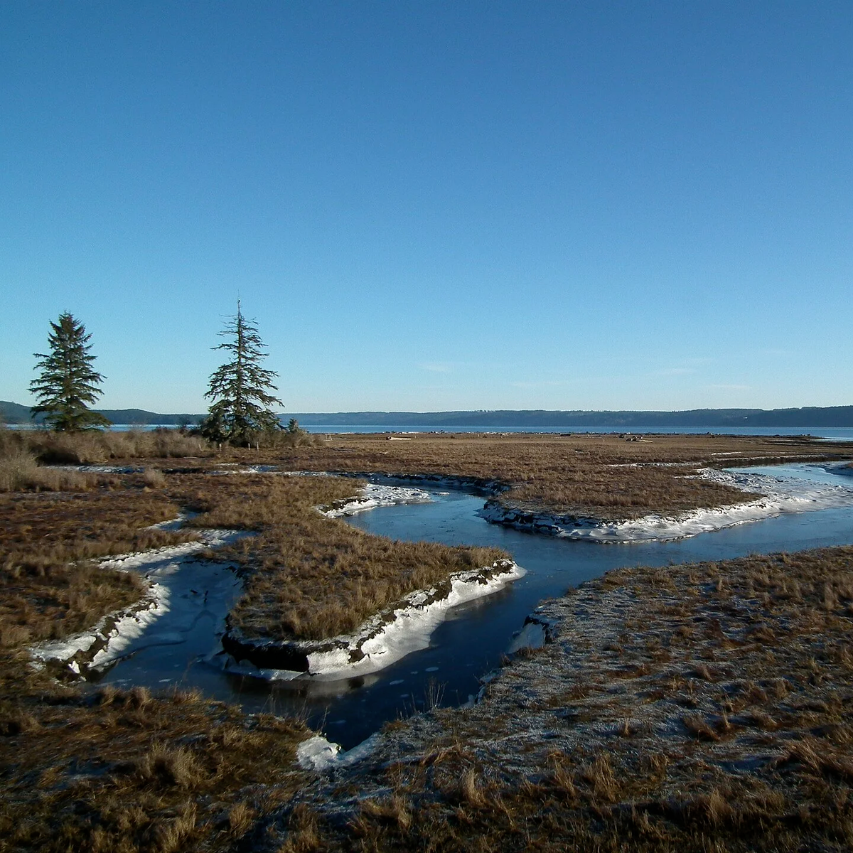
[caption id align="alignnone" width="1920"]
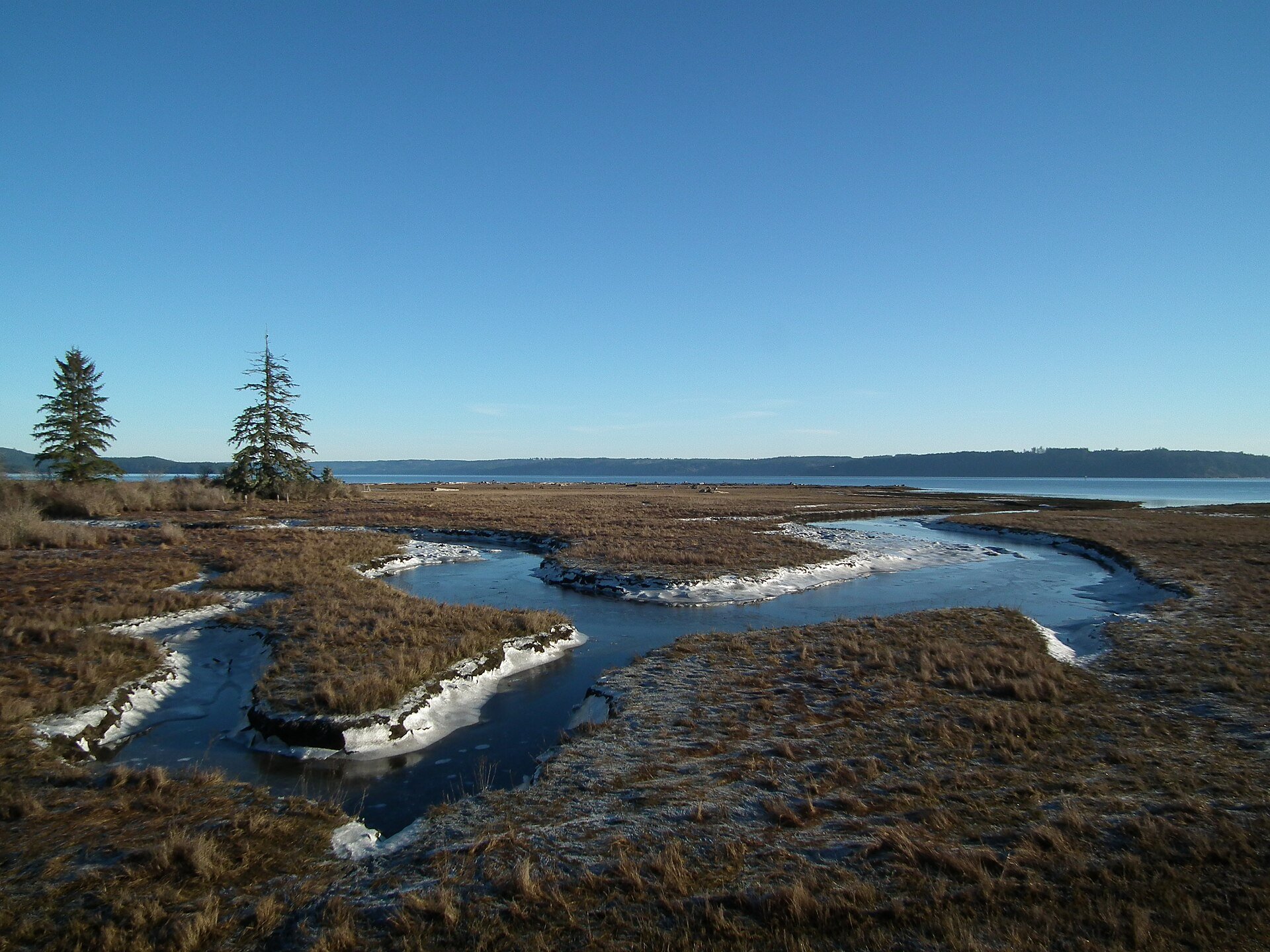
Tidal shoreline near the estuary of the Dosewallips River, Dosewallips State Park [/caption]
Explanatory journalism by Mark Rose
The behavior of the Dosewallips River dictates Brinnon’s future as a rural community. Most of Brinnon’s 66-acre Rural Village Center (RVC), which designates areas for small businesses and cottage industries—known as the Brinnon flats—lies within the 100-year floodplain of the Dosewallips River.
Residents considered relocating the town to higher ground, but regulations effectively prevent it. Despite extensive planning, Brinnon remains stagnant, with no new jobs, businesses, or services for the area, due to FEMA's floodplain designation.
Now, a coordinated effort by several government agencies and environmental groups, along with Brinnon residents who formed the South County Task Force (SCTF), aims to break the logjam. The goal is to finally resolve the floodplain issue and realize the Brinnon village that residents envisioned in their subarea plan.
Recent Progress
The Dosewallips River Collaborative (DRC) is an informal group of diverse entities focused on habitat restoration and floodplain control in the Dosewallips River watershed. The DRC has been attending meetings at the Brinnon Community Center organized by the South County Task Force. The DRC’s Dosewallips River Project has made significant progress in recent years.

The image above is from the July 30, 2025, presentation titled “Evaluation of Restoration Actions and Berm Treatments,” by Ecologist John Soden of Natural Systems Design. March 4, 2025, Soden also presented the DRC Dosewallips River Assessment, which addresses the “Brinnon Flood and Channel Migration Risk.” On November 4, 2023, Geomorphologist Tim Abbe, also of Natural Systems Design, presented a report studying the Rocky Brook and Powerlines Reaches.
Abbe’s report includes a fascinating study of the importance of engineered logjams in slowing the river and creating habitat. Brinnon pioneers faced huge logjams that stopped up and diverted the river. They developed creative ways to break up those logjams so the river could flow freely. However, smaller logjams on the sides or in the middle of a river are essential habitat for fish.
Although there is no confirmed case of the river flooding the town, and the chance of such an event is only one percent, a bend in the river borders the commercial area of Brinnon and remains a persistent hazard. Mitigating the floodplain is complicated by salmon restoration efforts and considerations of climate change.
The floodplain mitigation is a long-term solution, perhaps lasting five years or more, but there is an urgent need to repair a degraded berm that could threaten the town. Residents in the area want to handle the problem themselves, just like Brinnon pioneers have done since they arrived (See “Managing the River” below). Does the town need to flood – threatening residences, businesses, and individual septic systems – before they’re taken seriously, they wonder. No plan is currently in place to address this immediate need.
Managing the River
The Dosewallips River originates in two forks that join about five miles from the headwaters, at approximately 6,000 feet, and flows 28 miles into Hood Canal. The river contains some of the most diverse salmonid populations in Hood Canal, including Puget Sound Chinook and Hood Canal Summer Chum.
The name Dosewallips originates from a Twana Indian myth about a man named Dos-wail-opsh who was turned into a mountain at the river's source. There are also several Klallam legends about the "Great Changer," Doquebatl, who transformed a mythical Klallam chief into a mountain at the headwaters of the Dosewallips River.
The river lies within the traditional territories of the Coast Salish people, whose descendants include the Skokomish Indian Tribe, Jamestown S’Klallam Tribe, Port Gamble S’Klallam Tribe, Lower Elwha Klallam Tribe, and Suquamish Tribe. For thousands of years, the waters of Hood Canal and its tributaries have supported a thriving ecosystem that underpins their cultures.
In 2005, the Jefferson County Land Trust and the County teamed up to buy 65 acres along a 1.5-mile section of the river. They purchased it from Steven Swift, a member of the family that developed the Lazy-C. The land contains a high concentration of spawning chinook and the mouth of one tributary in which coho spawn and rear. It is also important as a floodplain, serving as a “safety zone” for flood waters, sediments, and debris, protecting the nearby town of Brinnon.
The Lazy-C was a homestead, then a farm, then a Dude Ranch, and then it was subdivided because the owner couldn’t pay the taxes, according to Brinnon pioneer Ida Bailey. The Lazy-C continually floods, sometimes catastrophically.
The December 2014 flood was so severe that the County Commissioners declared a State of Emergency, the Red Cross set up at the Brinnon Community Center, the Lazy-C flooded, and the Fire Department rescued people from the Canal Tracts by the Duckabush River.
“We’ve been here 23 years and have never seen waters this high. Both rivers have had their way with the community,” said Joy Baisch, who runs a Bed and Breakfast with her husband, Joe.
Ted Labbe, then habitat biologist for the Port Gamble S’Klallam Tribe, conducted detailed GIS and GPS surveys of the river, and the Tribe used other technologies and a helicopter flyover to create the 2005 Dosewallips River Assessment. Tribes have treaty-protected fishing rights on the river.
As part of that project, Labbe interviewed some Brinnon pioneers who lived in the Dosewallips River Valley. Among them were Vern and Ida Bailey, official Brinnon historians and authors of “Brinnon, a Scrapbook of History.” The Baileys lived on the river for 80 years. Ida Bailey was born in 1921 and raised in the Dosewallips River valley. Ida’s grandparents settled in the valley in 1906. Following is a summary of Labbe’s interview with the Baileys.
Ida Bailey remembers being five years old in 1926 when both sides of the river burned out. She recalled being taken into a field, lying on a blanket, and told to stay put while they fought to save the buildings. Her father was catching steelhead from the river, and the king salmon were so plentiful you could walk across them. The old growth would fall into the river, creating logjams. They would get on the logjams and fish from them. In November 1949, during a major flood, old-growth trees formed a dam across the river. The next year, they got a permit from the county and removed the logjam. They have many stories of protecting property and “fixing” the river. Vern says they pitched in to protect the Baisch property: “We put ‘shear logs’ to keep the river out of the field. We tied big logs off against the bank so that as the river rises, the logs would lift and keep debris out of the fields.” They tried a similar technique in their area, but the river didn’t cooperate and took about an acre of their land.
In the early days, logs harvested up the Dosewallips Valley were transported down to the Canal by railroad. The pioneers also used a splash dam to get the logs down to the Canal. Loggers would collect logs above the splash dam during winter, then open the gates in the spring to release a powerful surge of water and logs downstream. This method was dangerous and destructive, often damaging the logs and the environment.
Managing the river these days is a complex process that demands careful planning to achieve two goals: enhancing habitat and reducing flooding in Brinnon.
Since January 2025, the South County Task Force, has been meeting monthly at the Brinnon Community Center to address the floodplain issue. Brinnon resident Andrew Schwartz organized the SCTF, with active participation from Tami Pokorny of the county’s Environmental Public Health and George Terry of the Department of Community Development. Jefferson County PUD, the Department of Fish and Wildlife, the Economic Development Council, the Hood Canal Coordinating Council, and others have participated in these meetings.
“You don’t get anything done without community and engagement,” said Schwartz, who is also a Planning Commissioner and Executive Director of the North Hood Canal Chamber of Commerce. “We’re thankful for the numerous local and state officials who have helped us make progress, but the driving force of this effort is here in the community.”
The next South County Task Force meeting is scheduled for Tuesday, January 6, 2026, at 5:00 pm at the Brinnon Community Center. The public is welcome. For more information, contact Andrew Schwartz at sjcth.news@gmail.com. Sign up for the South County News email list here: https://forms.gle/snZDxn2D2rF5bu3C8
Also, at that meeting, the SCTF will kick off the effort to update the Brinnon Subarea Plan. Finalized in 2002, the plan was intended to be updated every five years.